SERVICES
Home > Services
Commercial Real Estate Photography
From a single property to entire multi-market portfolios, Tenfold Capture delivers visuals that highlight the true value of your assets. Whether you’re marketing a flagship building, repositioning a shopping center, or updating a national portfolio, our photography and videography help your properties stand out in competitive markets.
With experience spanning thousands of jobs and millions of square feet, we’ve become the trusted partner for developers, landlords, REITs, and brokerage firms coast-to-coast.
Our nationwide coverage means you’ll get consistent, high-quality results across all your properties — no matter the location.
Win Deals Faster
Professional visuals that capture attention and build buyer confidence
Highlight property strengths that accelerate leasing and sales decisions
Cinematic videos that tell a compelling investment story
Matterport 3D tours that shorten decision cycles for remote buyers
Custom angles and compositions that speak directly to investors’ priorities
Visuals tailored for offering memorandums and pitch decks
Showcase surrounding amenities and community assets to boost value perception
Before-and-after visuals that demonstrate repositioning potential
Save Time and Money
Retainer programs that cut costs dramatically compared to one-off projects
Streamlined booking with our quick online order form
Fast turnaround times — rush options available when needed
Flexible scheduling to align with your project timelines
Bundled services (photo, video, 3D, staging) for better value
Centralized delivery — everything in one package
Transparent, predictable pricing with no hidden fees
95% repeat clients trust us to deliver right the first time
Scale Nationally
Consistent photography standards across multiple markets
Nationwide coverage — from New England roots to coast-to-coast service
Coordinated scheduling for portfolios spanning dozens of properties
Single point of contact for all your markets
Reliable network of skilled photographers and drone pilots
Centralized editing team for uniform style and quality
Visuals tailored to both local leasing needs and national investment teams
Streamlined delivery
Flexible capacity to handle small assets or large, multi-state portfolios
Showcase Properties
High-impact exterior photography that makes listings stand out online and in print
Interior photography that highlights light, flow, and finishes
Twilight and dusk shots that add drama and warmth
Aerial imagery that shows scale, context, and surroundings
Detail shots that capture key features — lobbies, signage, amenities
Virtual staging to bring empty spaces to life
3D tours and floor plans that let prospects explore remotely
Cinematic video walkthroughs to tell a property’s story
Blue sky replacement and photo retouching for polished results


Inspection Videos
Harnessing the latest in drone technology, Tenfold Capture delivers fast, detailed, and cost-effective inspection services. From commercial facades and roofs to bridges, wind turbines, and cell towers—if you need eyes on it, we can capture it.
We specialize in:
Commercial roof and façade inspections
Bridge and infrastructure assessments
Wind turbine inspections
Cell tower and utility structure inspections
Property condition documentation
Ongoing construction monitoring
Due diligence inspections
Looking for ongoing monitoring? Ask about our unbeatable rates for monthly, quarterly, or semi-annual inspection packages for malls, strip plazas, and other commercial properties.
Inspection Videos are an incredible tool for:
Tenant Discussions
Property & Investment Evaluation
Legal, liability
Future planning
Insurance records
Inspection Videos also support:
Proactive maintenance planning
Contractor and vendor oversight
Project progress documentation
Compliance and safety reviews
Marketing and stakeholder updates
Environmental and site condition tracking
Don’t worry about traffic and no need for your camera and camcorder. Leave your notepad at home and we will fly every square inch of your property!

Orthomosaic Mapping
Capture massive multi-hundred-acre properties with precision, detail, and accuracy.
We leverage advanced software to stitch together thousands of drone photos to produce high quality orthomosaic maps.
See fine details with up to 0.7 in/px resolution.
Orthomosaic Mapping
Capture massive properties with precision, detail, and accuracy.
We use advanced software to stitch together thousands of drone photos to produce high quality orthomosaic maps.
See fine details with up to a couple millimeters of accuracy!
We deliver ALL the original photos used to stitch your map and deliver the following output formats:
Georeferenced Imagery Raster files that are compatible with most common GIS softwares
GeoTIFF High quality image at up to 300k x 300k.
DEM (DSM) GeoTIFF High quality image at 1/4 of GeoTIFF resolution. 32-bit elevations with NODATA.
Colorized DEM GeoTIFF High quality image at 1/4 of GeoTIFF resolution.
NDVI GeoTIFF High quality image at 1/2 of GeoTIFF resolution. Customizable color mapping. Red or Blue filtered input images.
Standard Imagery Image files that are suitable for printing or manual GIS work
Tiff High quality image at up to 300k x 300k.
JPG Compressed image at up to 300k x 300k.
Colorized DEM JPG Compressed image at 1/4 of GeoTIFF resolution.
NDVI JPG Compressed image at 1/2 of GeoTIFF resolution.
PRICING: $300 up to 30 acres, $400 up to 50 acres, call or email for larger areas


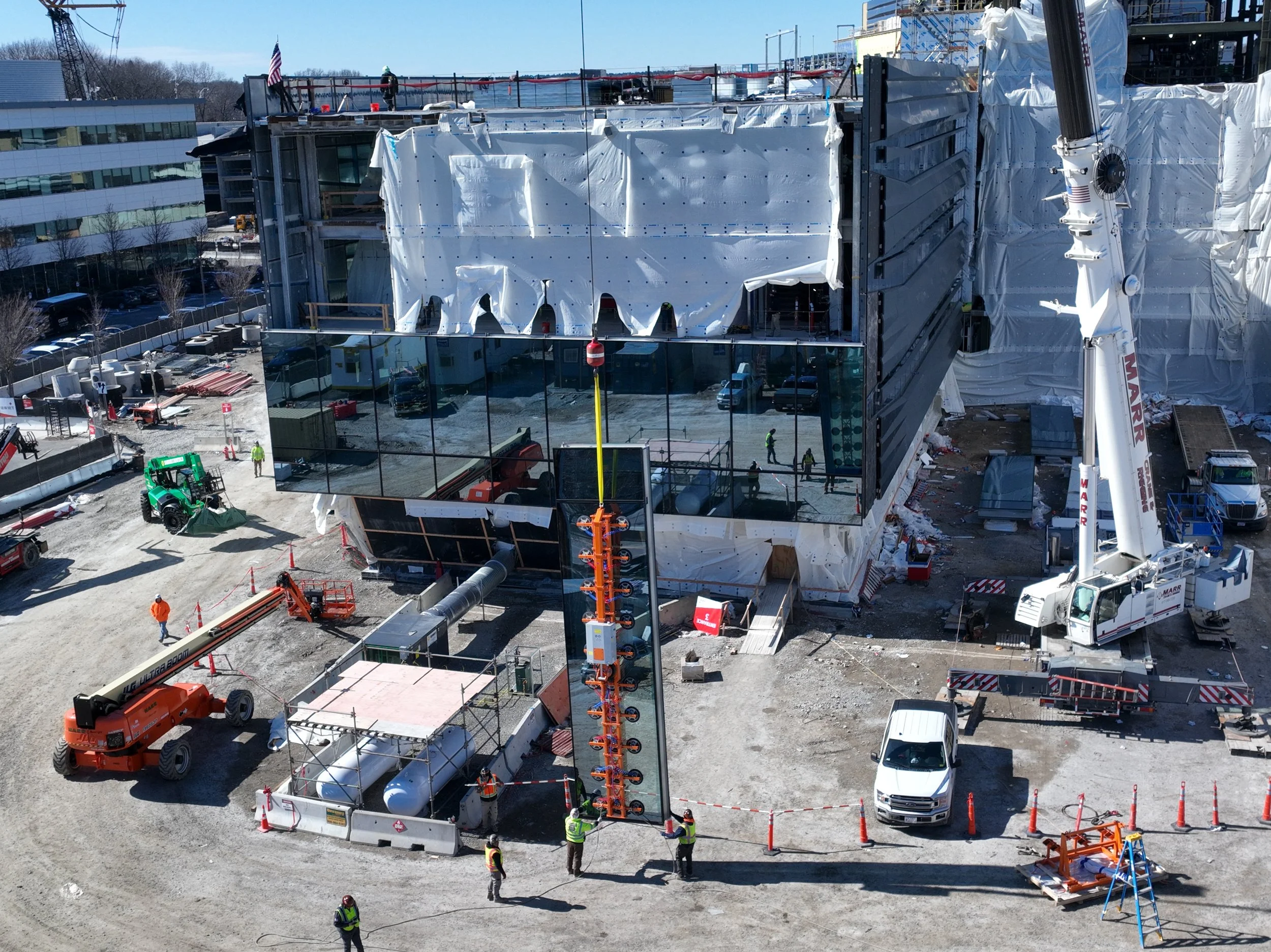
Construction Progress
Construction Progress Documentation
Tenfold Capture partners with construction companies to provide clear, consistent, and professional progress documentation. Whether it’s for legal compliance, client updates, investor reporting, or internal project management, we ensure every milestone is captured with accuracy and reliability.
Why Clients Trust Tenfold Capture
Consistent Angles & Views – We return to the same perspectives every time so you have an apples-to-apples record of site progress.
Flexible Scheduling – Weekly, monthly, quarterly, or even daily documentation, depending on the pace and needs of your project.
Trained & Certified Team – Our crew is OSHA-30 certified, FAA-licensed, fully insured, and experienced in navigating active construction sites safely.
Nationwide Coverage – From small local builds to multi-state portfolios, we can deploy teams wherever your projects are located.
Ready When You Need Us
Have a rush job and need images tomorrow? No problem. Our team is built to respond quickly and deliver on tight deadlines without sacrificing quality.
Built for Construction Environments
We understand that construction projects are dynamic, fast-moving, and require careful coordination. That’s why we prioritize:
Safety compliance on every site
Quick turnaround of deliverables
Clear communication with your project managers
Accurate archiving for your records and reporting needs
📞 Call us today to discuss your project needs.
Tenfold Capture delivers visuals that keep your clients informed, your teams aligned, and your projects moving forward.

“On our multi-year construction project, Tenfold Capture quickly became an essential part of our team.
Parker and his crew provided weekly construction monitoring that went far beyond simple progress photos. Every week, we received high-resolution ortho maps for CAD and project overlays that our engineers and architects relied on to verify accuracy and track real-time conditions in the field.
The video and photo deliverables weren’t just impressive visuals, they became working tools. We used them in weekly progress meetings with subcontractors, shared them with ownership groups and lenders to keep funding aligned, and even referenced them in coordination sessions with architects and consultants.
The consistency, professionalism, and safety-first approach Parker and his team brought to our site built trust immediately. They understood what mattered most to the construction process and delivered it on time, every time. Over the course of the project, Tenfold Capture wasn’t just a vendor, they became part of our extended team, highly trusted by everyone from field superintendents to executives. I can honestly say their work saved us time, reduced risk, and gave all stakeholders a clear view into the project from start to finish.
We will call Tenfold for our next large project”
”
3D Modeling
Produce valuable 3D models of construction sites, commercial properties, or buildings. With advanced software, we combine data from multiple images to produce your 3D models.
Visualize your property, measure volume, and calculate area.

Solar
Fast and accurate roof measurements, field surveys, construction update photos, inspections. Whatever your solar needs are: Tenfold Capture has you covered. We have performed 100’s of solar surveys and can even help you with drafting of plans. Contact us for more details!

Custom Requests
Get decision-enabling data from detailed aerial images for whatever your project requires. We’ll work with you to make sure we capture the images you need to get the data you are looking for.
Some of the varied projects we have worked on recently:
Traffic analysis
Beach erosion
Stockpile measurements
Agriculture analysis
Media needs
Wedding and social events
Radio tower inspection
Utility line inspection
Bridge inspection
BOTTOM LINE: If you need it done, we can do it.

Chappaquidick Island, © 2020 Parker Harrington